
Maps! So many of us love them. They take us places that we want to go or imagine that we would love to visit. But they also serve practical purposes for city planning. Recently I’ve been working on a project with a group of colleagues at the University of Melbourne’s Melbourne History Workshop. This project has taken one block of the city and is investigating the history of the site from pre-colonial days to the present. The site is the block (actually two blocks!) bounded by Swanston, Collins, Russell and Bourke streets, bisected by Little Collins. We are working with maps, newspapers, images, historical texts, museum collections and other sources that can give us an idea of the multiple historical layers of the site. As well as ‘traditional’ historical archival materials, we utilise digital humanities platforms (becoming increasingly important for the work we do as historians) and the mapping of the site and its histories through GIS and geospatial technology.
There are some fantastic sites out there at the moment using these types of technologies, such as Cleveland Historical, Collage: The London Picture Archive; and Digital Harlem. Sites like these are both digital treasure troves and digital rabbit holes. The first day I looked at Collage I ended up doing about four hours of research for my thesis and found numerous important sources that I would not have found through traditional means – mainly due to my physical distance from them.
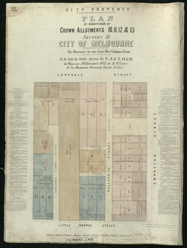
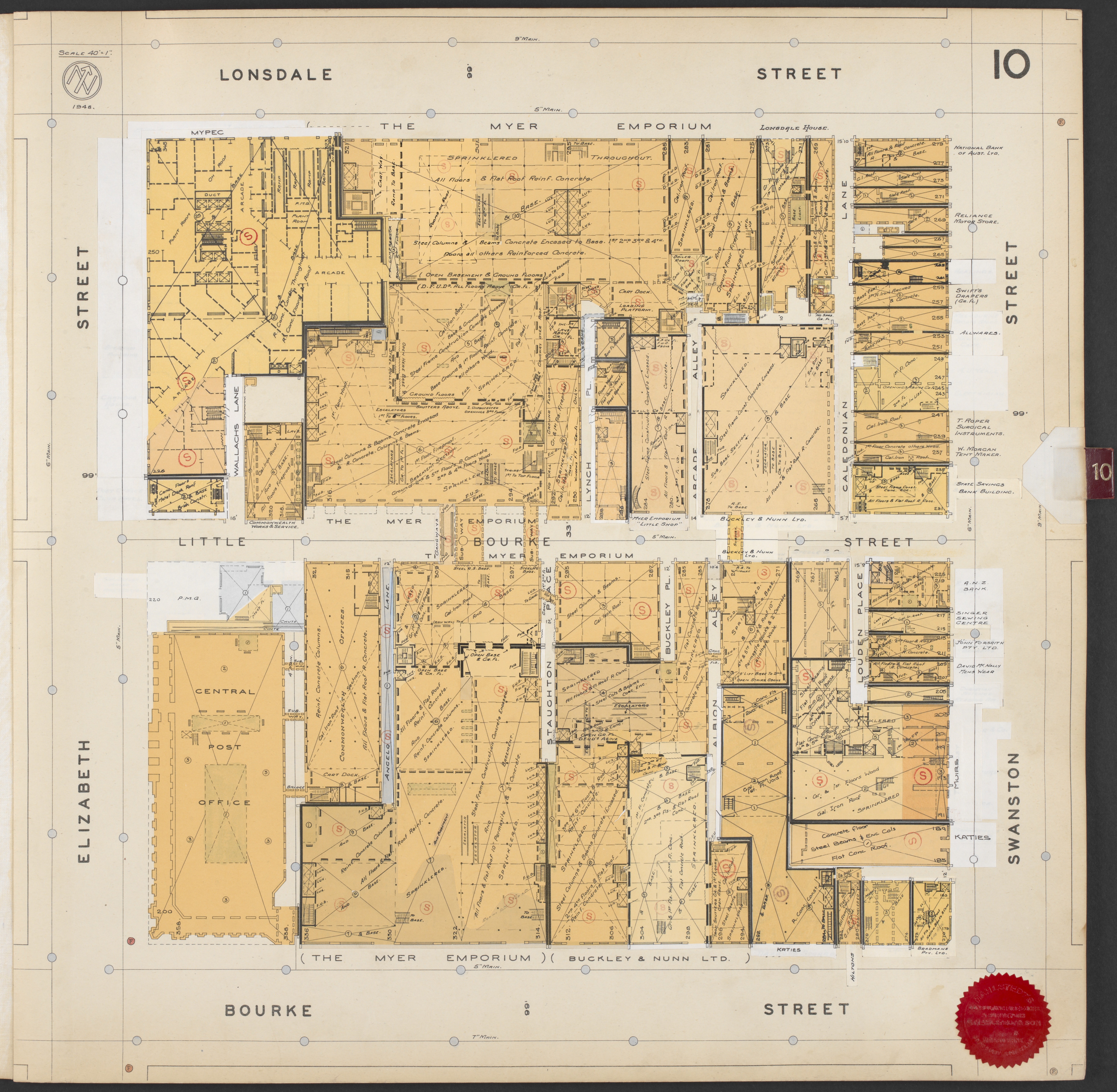
I have discussed before the importance of the idea of ‘layers of history’ to my project and the work on the project with the MHW team is part of my broader interest in researching the history of the city using this layered approach. Our inspiration for the project and the selection of the site came from a fire survey map that is in the collection of the State Library Victoria produced by surveyors Mahlstedt & Gee, which detail the buildings and even the occupants of those buildings in the city of Melbourne. They produced these maps over an approximately eighty-year period, once ever couple of decades, and by looking through them we can see the physical changes and growth that the city underwent. It’s quite amazing to see the increasing density and size of the built environment of the city through this period, as well as to explore what types of businesses were present.
After working on these maps for the block on which our project is focussed, I went back to the State Library’s website and collected them for the city blocks that each of the arcades were or are on. Below are a series of maps from Mahlstedt & Gee from the State Library Victoria, that show the evolution of the site on which the Queens Arcade in Lonsdale Street stood (they have even bigger zoomable versions on there, so I highly recommend having a look!). The first map is slightly earlier and is the land sale on which the properties owned by Rev James Clow, including the site of the Queens Arcade. Have a look at the changes that this city block underwent and let me know if you see anything that captures your attention!


Hi Nicole,
I loved your article! I was wondering if you had any more information or knowledge on the ‘Mahlstedt Plans’?
I have actually acquired a leatherbound copy of Brisbane CBD, which I believe was completed in 1951!
I’m not overly into architecture, but I love antiques and collectibles, and there’s something about this giant book that amazes me!
I can’t seem to find much information on them anywhere, or where there might be any other copies to look at?
Thank you for your time, and I hope to hear from you!
Regards,
Jacob
Hey there Jacob
Thanks so much for your kind words. I’m sorry I’ve taken so long to reply. How exciting that you’ve found them for Brisbane! I’m not sure if the Mahlstedt Fire Insurance Plans for Melbourne are specifically available in a book now somewhere (although that was their original form) but you may find them at auction or something. There is a little information on the State Library Victoria website and they have a good service where you can contact the librarians and perhaps gain a little more information. Glad you’ve enjoyed reading!
Hi, I am also a researcher. Love your work, but as always someone finds out that bit more. In 1853 a design is put to council for Melbourne’s first Arcade. This arcade is the brain child of the man I am researching. He wanted it to be called Victoria Arcade. The Governor on opening the Arcade gave it the Name ‘Queen’s Arcade’ much to the annoyance of the designer and project manager who defiantly still referred to the establishment as ‘Victoria Arcade’ some months after the opening. There never was a Victoria Arcade in existence.
Hi Bob! Thanks so much (and sorry for the late reply). Yes, lately I’ve been coming to that conclusion too that the proposed Victoria Arcade was never built, although the Tattersalls Horse Bazaar to which it was meant to back onto was built. This was definitely different to the Queens Arcade as different entrepreneurs proposed them. I’d love to hear more about your research if you’re willing to share further.
Hi Nicole,
On further research I have come to the conclusion that the Queens Arcade is the Victoria Arcade. The ‘project Manager’ for Tattersall’s and the Arcade being the same man. The ‘project manager’ even after the Queens Arcade completion and naming is still referred to by him, maybe in defiance, as the Victoria Arcade in newspaper articles. This man is also the pioneer who masterminded the beginnings of Queensland’s largest regional City in 1864.
Hi Bob. Are you referring to John Black? He definitely proposed the Victoria Arcade but wasn’t linked to the Queens as far as I can find and I’ve searched pretty thoroughly. The two arcades were definitely different buildings. They were on different streets (Queens on Lonsdale, Victoria on Bourke St). There are also newspaper advertisements for the proposed Victoria Arcade after the the Queens was already opened: plans for the Victoria Arcade are still on display in November while the Queens was opened in September. Architects of the Queens were Webb & Co, who put out tenders in February 1853, with the Melbourne Arcade Company made up of Morris Lee, Esq. Directors: Henry Holme, Esq., Richard Charles Luscombe, Esq.; Treasurer: Edward de Carle, Esq.; Secretary: Charles Charlton Pain, Esq. (Argus, 3 March 1853), but Black isn’t mentioned at all here. There is a lovely elaborate drawing of the building which give his name as the Victoria Arcade proprietor and indicate that it is located on Bourke Street not Lonsdale. I’d love to hear more though if Black was involved with the Queens as I’ve not been able to locate anything that indicates so and it would be great if he was involved! Such a character.